More than 30 colorful photo facts about Norilsk – Russia today Posting in CHAT: Russia Norilsk is the northernmost city in the world with a population of more than 150 thousand people. Much in the development of Norilsk differs from other cities - the location of houses and streets, construction technologies, architecture. And all this is closely connected with history and harsh northern conditions. Norilsk began as a Gulag prison - now this place is an "old" city, from which it turned into an industrial zone. And the “new” city was built from scratch. And this construction had its own characteristics - weak frozen soils, strong winds and frosts. There aren’t even trees here—they don’t take root. The geometry of Norilsk is designed so that the main streets are ventilated, and the houses in the blocks protect the interior from the wind. In the development you can see the influence of the Leningrad architectural school, Soviet standard houses - the city expanded until the collapse of the Soviet Union.1. The first building in Norilsk is a hut in which the expedition of N.N. Urvantsev wintered in 1926, when geologists discovered rich deposits. Now this hut stands near the Norilsk Museum. The deposits were developed by prisoners of Norilsk, so the first residential buildings here were barracks. But even before the disbandment of the camp, Norilsk became a real city. And when the former prisoners began to leave, Komsomol members poured into the city. The population continued to grow, and new residential buildings were needed to accommodate the townspeople. © Slava Stepanov/gelio.livejournal.com 2. “Permafrost” is not an entirely accurate term. Scientists prefer to say “permafrost.” In any case, it is difficult to build on such a foundation - the soil is weak and unstable. The layer below the first floor may melt - it is impossible to predict the structure of the foundation in such conditions. That is why residential buildings were initially built only on a stone foundation. It turned out to be expensive and time-consuming - sometimes, to get to the rock, it was necessary to dig a hole up to 20 meters deep. But a solution was found - to use the properties of permafrost. To do this, you need to drill a well and lay a reinforced concrete pile in it. And the main thing is to make a ventilated underground so as not to disturb the permafrost layer. Once the technology was tested, mass construction began. © Slava Stepanov/gelio.livejournal.com 3. The Gates of Norilsk are the main architectural ensemble, practically the face of the city. One of the houses is completely residential, the second is the Polar Star hotel. © Slava Stepanov/gelio.livejournal.com 4. In Soviet times they said that Norilsk is a piece of Leningrad. Indeed, some houses were designed by students of the Leningrad Architectural School. © Slava Stepanov/gelio.livejournal.com 5. Oktyabrskaya Square. At the entrance to the city there is a monument to Lenin - this is where Leninsky Prospekt, the main street of the city, begins. The monument was erected in 1954, when the avenue was still called Stalinsky. © Slava Stepanov/gelio.livejournal.com 6. Norilsk Museum The history of the museum begins in 1939, 4 years after the start of construction of the plant. The museum's first collection consisted of geological samples - local minerals and building materials. The museum moved several times, and in 1965 it was even closed for 6 years. The museum moved to a new building in 2000 - before that there was a cinema here. © Slava Stepanov/gelio.livejournal.com 7. Leninsky Prospekt. © Slava Stepanov/gelio.livejournal.com 8. Administration of Norilsk. © Slava Stepanov/gelio.livejournal.com 9. A new technology for building houses on stilts was proposed in 1950. Until 1951, the village of Norilsk and the industrial site of the Norilsk plant were located next to the first hut. Now this place is called the “old” city. This is an industrial zone, there are no residential buildings. In the late 1940s, design began, and in 1951, construction began on a “new” city on the eastern bank of the Dolgoy. © Slava Stepanov/gelio.livejournal.com 10. Norilsk Polar Drama Theater named after. Vl. Mayakovsky is the northernmost theater in the world. © Slava Stepanov/gelio.livejournal.com 11. © Slava Stepanov/gelio.livejournal.com 12. The camp barracks were rebuilt into a full-fledged city under the leadership of the Leningrad architect Vitoldo Nepokoichitsky. The first buildings of the city were made in the neoclassical style and were similar to those in St. Petersburg. © Slava Stepanov/gelio.livejournal.com 13. Hotel “Norilsk”. Soviet street. © Slava Stepanov/gelio.livejournal.com 14. Microdistrict No. 1. © Slava Stepanov/gelio.livejournal.com 15. Microdistrict No. 10. © Slava Stepanov/gelio.livejournal.com 16. Leninsky Prospekt. © Slava Stepanov/gelio.livejournal.com 17. Districts No. 31 and 7. © Slava Stepanov/gelio.livejournal.com 18. The master plan takes into account the features of the region - for example, Dolgoe and reservoirs in the south-west region, region. The composition is based on the main avenue with squares. © Slava Stepanov/gelio.livejournal.com 19. Microdistrict No. 7. © Slava Stepanov/gelio.livejournal.com 20. Closed houses protect the courtyard area from the wind - in Norilsk the wind speed can reach 40 m/s. This weather is called a “black blizzard” - visibility in windy and blizzard conditions is almost zero. © Slava Stepanov/gelio.livejournal.com 21. Youth passage. © Slava Stepanov/gelio.livejournal.com 22. Temple of the New Martyrs and Confessors of the Russian Church. © Slava Stepanov/gelio.livejournal.com 23. Sports and entertainment complex "Arena-Norilsk" © Slava Stepanov/gelio.livejournal.com 24. Microdistrict No. 15. © Slava Stepanov/gelio.livejournal.com 25. City cultural center. The intersection of Ordzhonikidze and Talnakhskaya streets. © Slava Stepanov/gelio.livejournal.com 26. Norilsk Interdistrict Hospital No. 1. © Slava Stepanov/gelio.livejournal.com 27. One of the main tasks of the architects was to reduce the influence of strong winds. At first it was assumed that if the streets were laid along the axes of the prevailing winds, they would carry snow outside the districts. But there is so much snow here that no wind can blow it away. As a result, it was decided to build compact gated communities so that the buildings would protect the interior from the wind. © Slava Stepanov/gelio.livejournal.com 28. A bridge across the Norilsk River, connecting Norilsk and the Talnakh region by road and rail. © Slava Stepanov/gelio.livejournal.com 29. Quarter No. 12. © Slava Stepanov/gelio.livejournal.com 30. © Slava Stepanov/gelio.livejournal.com 31. © Slava Stepanov/gelio.livejournal.com 32. V V In December 2021, the government approved a comprehensive plan for the socio-economic development of Norilsk until 2035. It is expected that more than 70 new houses, two kindergartens, a school and a clinic will appear in the city. More than 40 dilapidated houses will be demolished, and several historic buildings in the center will be restored. So perhaps in the next report about Norilsk changes in the geometry of the city will be noticed. © Slava Stepanov/gelio.livejournal.com Source Source link Source link
от
bonabo
8371
от
bonabo
Россия
10189
Более 30 красочных фотофактов о Норильске
Норильск – самый северный город мира с населением более 150 тысяч человек. Многое в застройке Норильска отличается от других городов – расположение домов и улиц, технологии строительства, архитектура. И все это тесно связано с историей и суровыми северными условиями. Норильск начинался с тюрьмы ГУЛАГа – теперь это место является «старым» городом, из которого оно превратилось в промышленную зону. И «новый» город строился с нуля. И у этого строительства были свои особенности – слабые мерзлотные грунты, сильные ветры и морозы. Здесь даже деревьев нет — они не приживаются. Геометрия Норильска спроектирована так, что главные улицы продуваются, а дома в кварталах защищают внутренние помещения от ветра. В развитии можно увидеть влияние ленинградской архитектурной школы, советских типовых домов – город расширялся вплоть до распада Советского Союза.1. Первой постройкой в Норильске является хижина, в которой зимовала экспедиция Н. Н. Урванцева в 1926 году, когда геологи обнаружили богатые месторождения. Сейчас эта хижина стоит возле Норильского музея. Месторождения разрабатывали узники Норильска, поэтому первыми жилыми постройками здесь были бараки. Но еще до расформирования лагеря Норильск стал настоящим городом. А когда бывшие заключенные стали уходить, в город хлынули комсомольцы. Население продолжало расти, и для размещения горожан требовались новые жилые дома. © Слава Степанов/gelio.livejournal.com 2. «Вечная мерзлота» — не совсем точный термин. Ученые предпочитают говорить «вечная мерзлота». В любом случае, на таком фундаменте строить сложно – грунт слабый и неустойчивый. Слой ниже первого этажа может расплавиться – спрогнозировать устройство фундамента в таких условиях невозможно. Именно поэтому жилые дома изначально строились только на каменном фундаменте. Это оказалось дорого и долго – иногда, чтобы добраться до скалы, приходилось вырыть яму глубиной до 20 метров. Но решение было найдено – использовать свойства вечной мерзлоты. Для этого нужно пробурить скважину и заложить в нее железобетонную груду. И главное сделать вентилируемое подполье, чтобы не нарушать слой вечной мерзлоты. Когда технология была опробована, началось массовое строительство. © Слава Степанов/gelio.livejournal.com 3. Ворота Норильска – главный архитектурный ансамбль, практически лицо города. Один из домов полностью жилой, второй — отель «Полярная звезда». © Слава Степанов/gelio.livejournal.com 4. В советские времена говорили, что Норильск – это кусочек Ленинграда. И действительно, некоторые дома спроектированы студентами Ленинградского архитектурного училища. © Слава Степанов/gelio.livejournal.com 5. Октябрьская площадь. При въезде в город установлен памятник Ленину – именно здесь начинается Ленинский проспект, главная улица города. Памятник был установлен в 1954 году, когда проспект еще назывался Сталинским. © Слава Степанов/gelio.livejournal.com 6. Норильский музей История музея начинается в 1939 году, через 4 года после начала строительства завода. Первая коллекция музея состояла из геологических образцов – местных минералов и строительных материалов. Музей несколько раз переезжал, а в 1965 году его даже закрыли на 6 лет. В новое здание музей переехал в 2000 году – до этого здесь был кинотеатр. © Слава Степанов/gelio.livejournal.com 7. Ленинский проспект. © Слава Степанов/gelio.livejournal.com 8. Администрация Норильска. © Слава Степанов/gelio.livejournal.com 9. Новая технология строительства домов на сваях была предложена в 1950 году. До 1951 года рядом с первой избой располагались поселок Норильск и промплощадка Норильского завода. Сейчас это место называют «старым» городом. Это промышленная зона, жилых домов нет. В конце 1940-х годов началось проектирование, а в 1951 году началось строительство «нового» города на восточном берегу Долгого. © Слава Степанов/gelio.livejournal.com 10. Норильский полярный драматический театр им. Вл. Маяковского – самый северный театр в мире. © Слава Степанов/gelio.livejournal.com 11. © Слава Степанов/gelio.livejournal.com 12. Лагерные бараки были перестроены в полноценный город под руководством ленинградского архитектора Витолдо Непокойчицкого. Первые здания города были выполнены в неоклассическом стиле и похожи на петербургские. © Слава Степанов/gelio.livejournal.com 13. Гостиница «Норильск». Советская улица. © Слава Степанов/gelio.livejournal.com 14. Микрорайон №1. © Слава Степанов/gelio.livejournal.com 15. Микрорайон №10. © Слава Степанов/gelio.livejournal.com 16. Ленинский проспект. © Слава Степанов/gelio.livejournal.com 17. Районы №31 и 7. © Слава Степанов/gelio.livejournal.com 18. В генеральном плане учтены особенности района - например Долгое и водохранилища на юго-западе область, край. В основе композиции лежит главный проспект с площадями. © Слава Степанов/gelio.livejournal.com 19. Микрорайон №7. © Слава Степанов/gelio.livejournal.com 20. Закрытые дома защищают дворовую территорию от ветра – в Норильске скорость ветра может достигать 40 м/с. Такую погоду называют «черной метелью» — видимость при ветре и метели почти нулевая. © Слава Степанов/gelio.livejournal.com 21. Молодежный проезд. © Слава Степанов/gelio.livejournal.com 22. Храм Новомучеников и Исповедников Церкви Русской. © Слава Степанов/gelio.livejournal.com 23. Спортивно-развлекательный комплекс «Арена-Норильск» © Слава Степанов/gelio.livejournal.com 24. Микрорайон №15. © Слава Степанов/gelio.livejournal.com 25. Городской культурный центр . Пересечение улиц Орджоникидзе и Талнахской. © Слава Степанов/gelio.livejournal.com 26. Норильская межрайонная больница № 1. © Слава Степанов/gelio.livejournal.com 27. Одной из главных задач архитекторов было снизить влияние сильных ветров. Сначала предполагалось, что если улицы прокладывать по осям господствующих ветров, то они будут выносить снег за пределы районов. Но снега здесь так много, что никакой ветер не сможет его сдуть. В результате было решено построить компактные закрытые кварталы, чтобы здания защищали внутренние помещения от ветра. © Слава Степанов/gelio.livejournal.com 28. Мост через реку Норильскую, соединяющий Норильск и Талнахский район автомобильным и железнодорожным транспортом. © Слава Степанов/gelio.livejournal.com 29. Квартал № 12. © Слава Степанов/gelio.livejournal.com 30. © Слава Степанов/gelio.livejournal.com 31. © Слава Степанов/gelio.livejournal.com 32. В В декабре 2021 года правительство утвердило комплексный план социально-экономического развития Норильска до 2035 года. Ожидается, что в городе появится более 70 новых домов, два детских сада, школа и поликлиника. Более 40 ветхих домов будут снесены, а несколько исторических зданий в центре отреставрированы. Так что возможно в следующем репортаже о Норильске будут замечены изменения в геометрии города. © Слава Степанов/gelio.livejournal.com Источник Source link
от
bonabo
8472
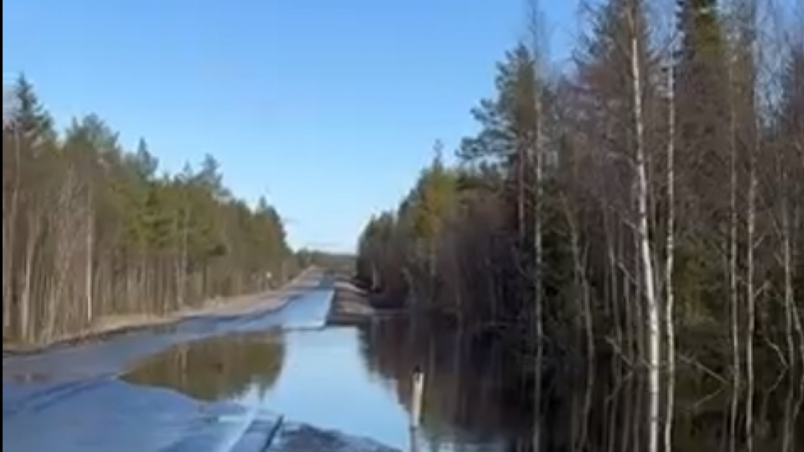
Federal highway “Kola” is flooded [видео] – Russia today Posting in CHAT: Russia News | 16 05 2024, 20:33 | SeverPost Video: VKontakte / Murmansk The federal highway R-21 “Kola” is flooded in the Murmansk region. A lake on the road formed in the area between Kandalaksha and Zelenoborsk, reports the Murmansk group on VKontakte. There is water on the road and cars drive in the center of the road, which looks safer. Let us remind you that an avalanche danger has been declared in Kirovsk. Read also: “Supporting the families of SVO participants is the task of the authorities” To be the first to know about the main news and the most important events of the day, subscribe to our Telegram channel. Source link Source link